We started our hike up at Glacier Point. We had our traveling companions David and Gloria Hood drive us up to Glacier Point after parking our van down in the valley. When you're up at Glacier Point and you look over the gorge to the waterfalls the Panorama trail takes you over to those waterfalls. To the top of them and down into Yosemite Valley.
Initially the trail head was a little hard to find, but you can see here that once we found the trail it was fairly open and we had no problems along the rest of the hike.
At 2.61 miles you come to Illiloutte Falls, Illiloutte Falls is sometimes called the "hidden falls" since it cannot be seen from Glacier Point or from the valley floor. About a mile and a half into the hike, Illiloutte Falls comes into view. A fellow hiker sits on the edge having a great view of the falls.
After Illiloutte Falls the trail begins to climb allowing great views of Yosemite Valley. In this photo you can see the top section Yosemite Falls. We estimated that we climbed back up 1000-1200 feet before starting to descend again. The trail has asphalt pavement remnants running nearly-continuously from Illilouette Creek to Nevada Falls.
In addition to great views of the lower valley, we had an excellent view of Half Dome. In the summer there are cables up which assist climbers to hike up to the top of the dome. This is one of the most popular and demanding climbs in the park. They only allow 70 climbers at any one time to ascend the mountain. From Yosemite Valley, it encompasses a 4,800 foot gain in elevation over a 8.5 mile trail.
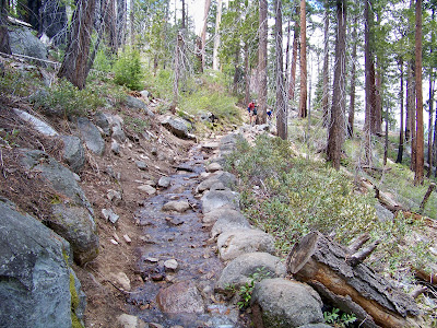
On our way down the mountain we came across several man-made stream beds to help funnel water down. There was plenty of water in the stream as Yosemite had an impressive snow season this year.
Here you can see fellow hikers negotiating about a 40 foot section of water filled trail. Kathy and I had already managed this area.
The hardest part of the hike for us was from Nevada Falls to Vernal Falls. It is all downhill on steep steps and we were tired. Very hard on the knees. But the view made up for the shaky legs and we found the Panorama trail to be a superior hiking trail. We considered this hike to be comparable in difficulty to the South Kaibab Trail at the Grand Canyon.
Both Nevada Falls and Vernal Falls made a great deal of noise for the amount of water in them. Nevada could be heard from many parts of the trail, but Vernal's noise was pretty much confined to the canyon below it.
We hiked this trail on June 1, 2011. There was no crowd on the trail until we hit Nevada and Vernal Falls. We felt like we had this hiking trail all to ourselves! At first, you cannot tell how long the staircase is and just when it looks to end to a dirt trail, it begins again. The trail descends 1000 feet to the bottom via over 600 steps of steep granite steps. When I started this post, I decided to search the Internet to see if I could find just how many steps we had to deal with.
You can see the impressive white water in the falls. It was intense to say the least. Many signs were posted throughout the trail to remind hikers to stay out of the water.
At the top of Nevada Fall, the trail joins the Mist and John Muir Trails to Happy Isles. We decided to return via the Mist Trail. Had I known what Kathy knew about this part of our trip, I might have suggested we take the easier John Muir Trail. The Muir Trail eliminates the two waterfalls. You have to remember we hiked 6.14 miles to this point. After the hike, I was glad we decided to see both waterfalls.
It's a 3-mile demanding round trip hike with a elevation gain of 1000 feet to the top of Vernal Fall from Yosemite Valley.
They don't call it the Mist Trail for nothing, prepare for slippery footing and a tremendous amount of waterfall spray. We were very tired when we arrived at this point. I just remember trying not to trip on any steps. I did not even turn around to check and see how Kathy was navigating the steps.
Here's a posting of other hikes that can be done in the High Sierra Area. You don't know how much I appreciated seeing this sign post. It meant the end of our hike! The hike took us 3 hours and 40 minutes of actual moving time. We used another hour plus to stop, take pictures, eat lunch, eat snacks and rest. We both truly enjoyed the hike but I don't think I will be doing it again any time too soon.


What a beautiful hike but oh so strenuous! We've been following your blog since your questions posted on RV.net regarding your Grand Canyon trip. Since hiking down the canyon myself and also volunteering by giving lighthouse tours in many places, I had a knee replacement in January. So....please keep that in mind for your future hikes and take care of those knees! Your blog is very well done. Thanks for good reading and great pics. We have been full-time RVers for almost 16 years and still love it!
ReplyDelete